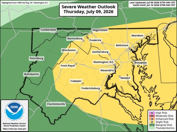
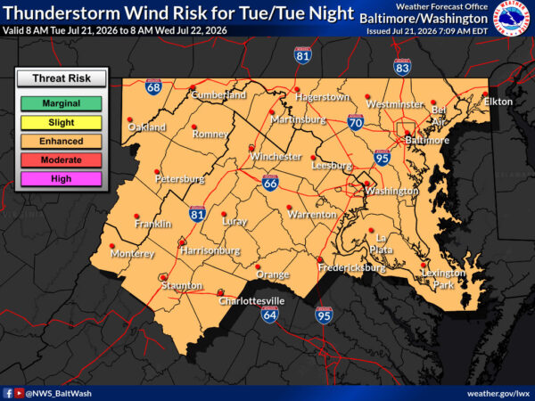
“A severe thunderstorm watch has been issued for parts of District of Columbia, Maryland, Virginia and West Virginia until 11 PM EDT,” NWS Wakefield announced.

Scattered showers and thunderstorms are expected this afternoon after 5 p.m. with a 30% chance of precipitation, increasing to likely showers and thunderstorms tonight before 11 p.m. with a 70% chance.


“Scattered severe thunderstorms are possible this afternoon and evening as a cold front tracks south through the Mid-Atlantic. Lightning, damaging gusty winds, and isolated hail are possible.” NWS Baltimore-Washington reported.

Showers and thunderstorms are likely tonight before midnight, then isolated showers between midnight and 1am. Low around 65. Monday brings mostly sunny skies with a high near 82 and northwest winds 10 to 15 mph with gusts up to 21 mph.


“Drier conditions on Saturday as high pressure moves into the Mid-Atlantic. Severe thunderstorm chances return on Sunday with an incoming cold front from the northwest,” NWS Baltimore-Washington reported. “Somewhat cooler temperatures and mostly cloudy conditions are expected Monday.”

Today features sunny skies with a high near 90. Sunday brings a 60% chance of showers and thunderstorms, a high near 94 with heat index values up to 100, followed by a 40% chance of storms Sunday night. Monday looks mostly sunny with a high near 81.


“The higher probabilities of damaging winds generally along and east of the Blue Ridge,” the National Weather Service reported. “Some of the storms could be severe.”

This afternoon and evening will bring showers and thunderstorms likely mainly after 5 p.m., with a high near 99 and heat index values as high as 107. Severe storms are possible with a 60% chance of precipitation. Tonight, additional showers and thunderstorms are likely mainly before 9 p.m. with an 80% chance. Saturday looks much drier and cooler with mostly sunny skies and a high near 90, while showers could return Sunday.


“Strong to severe thunderstorms remain possible today and Friday amid a hot, humid, and unstable atmosphere,” the National Weather Service reported. “Heavy rain, gusty winds, and isolated hail are possible during the afternoon & evening hours. Additionally, heat indices of 100º to 105º F are possible.”

Today will be mostly sunny with a high near 96 and heat index values as high as 101, followed by a chance of showers and thunderstorms tonight. Friday brings likely showers and thunderstorms with a high near 97 and heat index up to 103, before drier conditions return Saturday with a high near 90.


Early morning radar showed widespread showers moving across the region on Wednesday, according to the National Weather Service. Brief heavy downpours and lightning are possible with some activity through 10 a.m., which could create wet roads and lower visibility during the morning commute.

Showers and thunderstorms are expected before 3 p.m., followed by more showers and possibly a thunderstorm mainly after 3 p.m. Patchy fog is possible between 8 a.m. and 9 a.m. Highs will reach near 87 with a 100% chance of precipitation and new rainfall amounts between a tenth and a quarter of an inch, though higher totals are possible in thunderstorms.


“There is a chance of t-storms west of I-81. Otherwise, more clouds than sun and increasing humidity,” National Weather Service Baltimore/Washington announced. “Much hotter and more humid by mid-week with increased thunderstorm chances.”

Today will be mostly cloudy with a high near 83. A chance of showers arrives tonight, followed by a 50% chance of showers and thunderstorms Wednesday with a high near 89. Thunderstorm chances continue into Thursday with a high near 95.


“Dry & seasonable warmth expected to start the work week,” National Weather Service Baltimore-Washington reported. “Hot & humid conditions w/ daily showers & t-storms return to the forecast Wednesday through the end of the week. The hottest conditions are most likely Thursday and Friday when peak heat indices could reach 100 to 105º F.”

The National Weather Service is warning of dangerous heat and humidity building midweek across the region, with peak heat indices potentially hitting 100–105°F on Thursday and Friday.


Northern Virginia, Maryland suburbs, and the greater D.C. region will experience continued early summer heat this week, with a brief cool-down early in the week followed by a warming trend and increasing chances for showers and thunderstorms mid-to-late week.

A strong-to-severe thunderstorm risk will affect northern portions of the area on Sunday, mainly along and north of the I-66 corridor. Damaging winds are the primary concern, with only a low conditional risk of hail in stronger storms.


View More Stories