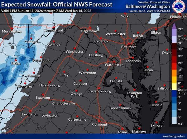
Get ready for a sharp drop in temperatures and gusty winds as a strong cold front moves through the region tonight into Thursday morning, according to the National Weather Service.
Forecast Overview
Get ready for a sharp drop in temperatures and gusty winds as a strong cold front moves through the region tonight into Thursday morning, according to the National Weather Service.
Forecast Overview
Update 11:45 a.m. — From Stafford fire and rescue’s Facebook page:
Original post — Good morning! Here’s a look at today’s weather forecast from the National Weather Service.
Press release:
The Metropolitan Washington Council of Governments (COG) has forecast a Code Orange air day for tomorrow, August 27 in part of the metropolitan Washington region, including DC and Northern Virginia as well as Suburban DC in Maryland (Prince George’s County and Lower Montgomery County). Code Orange levels mean the air is unhealthy for sensitive groups.
The National Weather Service has issued a severe thunderstorm warning for Stafford County, including Aquia Harbour and King George, effective until 3:15 p.m. today. This warning comes as a series of storm clusters, currently over Johnstown, PA, and extending across Lake Erie, are expected to intensify as they approach the region.
As of 9:45 a.m., satellite and radar imagery showed several clusters of showers accompanied by occasional lightning moving southeastward.
The National Weather Service has issued a severe thunderstorm watch for the region until 10 p.m. on Sunday, August 18. A slow-moving cold front will bring showers and thunderstorms throughout the day. The highest chances of precipitation are expected this afternoon and evening as the front moves across the area.