

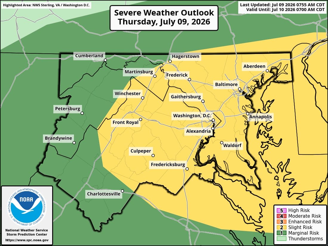
The National Weather Service office in Baltimore/Washington has expanded a Flood Watch and Slight Risk of severe thunderstorms westward to cover additional portions of the Shenandoah Valley and the I-81 corridor.
A surface front and a strong shortwave moving from the Ohio and Tennessee Valleys will bring widespread thunderstorm activity to the region through Friday. Ample moisture from a tropical air mass, with precipitable water values of 2 to 2.25 inches, will support heavy rainfall.
This afternoon, expect showers and possibly a thunderstorm. Some storms could produce heavy rainfall. Highs will reach near 88°F with south winds around 6 mph. The chance of precipitation is 90 percent. Rainfall amounts are forecast between a tenth and quarter of an inch, with higher totals possible in thunderstorms.
Tonight, showers and a possible thunderstorm are likely before 8 p.m., followed by isolated activity between 8 and 9 p.m. Lows will drop to around 70°F with calm winds. Chance of precipitation is 80 percent, with new rainfall under a tenth of an inch except in stronger storms.
Friday will feature showers likely, with a possible thunderstorm between 3 and 5 p.m., followed by scattered activity. Highs near 91°F. Chance of precipitation is 60 percent.
Today, the Storm Prediction Center’s Slight Risk of severe thunderstorms has been expanded westward due to increased sunshine and instability. Damaging wind gusts remain the primary severe hazard, along with frequent lightning and torrential downpours. Convection is expected to initiate off higher terrain in the early afternoon and track toward the I-95 corridor by late afternoon and early evening.
The Flood Watch, in effect from 2 p.m. through 11 p.m., covers north-central Maryland south into northern Virginia and eastward, with a Slight Risk of excessive rainfall noted north of I-64 by the Weather Prediction Center. Recent heavy rains and urban areas along the I-95 corridor face elevated flash flood risk. Intense rainfall rates of 2 to 3 inches per hour are possible.
Some convective threat may linger into Friday afternoon and evening, particularly if prior rainfall saturates the ground. Friday marks the warmest day remaining in the work week, with highs in the upper 80s to low 90s.
Looking ahead, a cold front will bring cooler and less humid conditions this weekend into Monday, with lingering shower chances. Temperatures are expected to moderate before above-average heat returns by mid-next week, though with lower humidity than the recent stretch.
Both the Flood Watch and the Slight Risk of severe thunderstorms were expanded westward to include more areas of the Shenandoah Valley and the I-81 corridor. #DCwx #MDwx #VAwx #WVwx pic.twitter.com/bHwKrdLy4u
— NWS Baltimore-Washington (@NWS_BaltWash) July 9, 2026
