
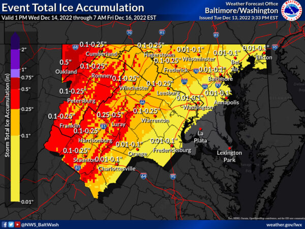
A Winter Storm Watch has been issued from 7 p.m. Wednesday through 10 p.m. Thursday for areas to our west, for parts of the Blue Ridge, Shenandoah Valley, and points west for more significant icing potential.
Drivers should be alert for a wintry mix of sleet and freezing rain that will impact roads late Wednesday night through Thursday morning. In addition to sleet and freezing rain, moderate to heavy rain may lead to ponding on roads.
VDOT asks those with plans to travel west to monitor the forecast and limit travel.
Right now, crews are pretreating roads tonight into Wednesday, but drivers are asked to prepare now for impacts to the Thursday morning rush hour. Crews will begin staging along roads Wednesday night.
National Weather Service forecast for our area:
Wednesday
Increasing clouds, with a high near 43. Light north wind.
Wednesday Night
A chance of rain before 10 pm, then rain and sleet between 10 pm and 4 am, then rain, possibly mixed with freezing rain and sleet after 4 am. Low around 31. Light northeast wind. The chance of precipitation is 90%. Little or no ice accumulation is expected. New sleet accumulation of less than a half inch is possible
Thursday
Rain, possibly mixed with freezing rain and sleet, becomes all rain after 10 am, high near 47. Light east wind increasing to 11 to 16 mph in the morning. Winds could gust as high as 23 mph. The chance of precipitation is 100%. Little or no ice accumulation is expected. New sleet accumulation of less than a half inch is possible.
Thursday Night
Rain is likely, mainly before 1 am. Mostly cloudy, with a low of around 36. Northeast wind 11 to 16 mph, becoming northwest after midnight. Winds could gust as high as 24 mph. The chance of precipitation is 70%.