
Our region is on alert this afternoon, evening, and overnight for severe weather.
The severe weather could come in two rounds, according to the National Weather Service. The first would come during the afternoon, with a few of the storms being severe with locally damaging winds, and, possibly with an isolated tornado.
Fooding is possible with these storms.
The second round is expected later this evening and overnight. The main threat of these storms will be a long line of damaging winds, with the possibility of an isolated tornado, hail, and flooding.
The severe weather will move ahead of a cold front coming through the region. It’s expected to be near the Interstate 95 corridor on Monday morning, according to the Weather Service.
If a tornado is headed your way, you’ll know it as it sounds like a large fright train. Large hail can also be a sign that a funnel cloud is nearby.
There are places you can seek shelter from a tornado.
According to the CDC, falling and flying debris cause most deaths and injuries during a tornado. Although there is no completely safe place during a tornado, some locations are much safer than others.
• Go to the basement or an inside room without windows on the lowest floor (bathroom, closet, center hallway).
• Avoid windows.
• For added protection get under something sturdy (a heavy table or workbench). Cover your body with a blanket, sleeping bag or mattress. Protect your head with anything available.
• Do not stay in a mobile home.
If you are outside or in a mobile home, find a nearby building preferably with a basement. If you are in a car, do not try to outrun a tornado but instead find the nearest sturdy building.
Prior to the incoming severe weather on Sunday, temperatures will top nearly 80 degrees, with mostly cloudy skies.
On Monday, gusty winds will develop behind the cold front, and high temperatures will be in the low 60s. Monday night, expect lows in the low 40s with gusty winds.
Updated
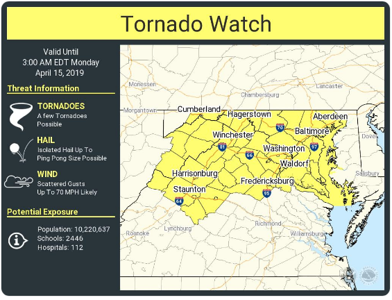
A tornado watch is in effect for our region until 3 a.m., according to the National Weather Service.
The watch means that conditions are favorable for tornados to develop.
A tornado warning means that radar has indicated a possible tornado on the ground, and those in its path should take cover.
According to radar, a line of heavy storms will push through our region about 1 a.m. as part of a cold front.
Heavy rain, hail, strong wind gusts, and isolated tornados