
A strong cold front moving through the region today is expected to bring a line of powerful thunderstorms, prompting a Level 3 (Enhanced Risk) for severe weather across much of Northern Virginia, including the I-95 corridor, according to the National Weather Service in Sterling.
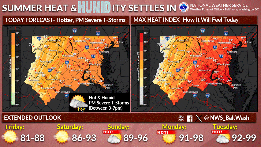
As of 11 a.m., temperatures were already soaring into the mid to upper 80s, with oppressive humidity making it feel even hotter. At Washington National Airport, it was 84°F with a heat index of 91°F. In Fredericksburg, it was 86°F and sunny, with wind gusts reaching 18 mph. Baltimore’s Inner Harbor was already reporting a temperature of 91°F and a heat index near 99°F.
Forecasters say storms could begin forming over the mountains by early afternoon and intensify as they move eastward. The highest threat for damaging winds, large hail, and heavy rainfall will occur between 3 and 7 p.m., especially in urban areas like Manassas, Woodbridge, and Fredericksburg. An isolated tornado or two can’t be ruled out.
“All hazards are on the table today,” meteorologists warned in a forecast discussion Thursday morning. “Storms will feed off high heat and humidity, making for an active afternoon.”
Temperatures are expected to climb into the upper 80s to low 90s ahead of the storms, with heat indices around 100 degrees. The combination of heat, humidity, and wind shear makes for a potentially dangerous setup.
Heavy downpours could also lead to localized flash flooding, especially in areas that have received recent rainfall. Storms may dump one to two inches of rain in under an hour, and runoff could be a concern in low-lying or urban areas.
Storm activity is expected to clear the region between 8 and 11 p.m., leaving behind cooler, drier air.
Looking Ahead:
- Friday: Relief arrives with highs in the mid-80s, lower humidity, and sunny skies. A stray shower is possible near the Maryland-Pennsylvania border, but most of the region will stay dry.
- Saturday: Warmer but still pleasant with highs in the upper 80s to low 90s and moderate humidity. Dry conditions are expected during the day.
- Sunday and Beyond: A prolonged stretch of heat is on the way. Temperatures will climb back into the 90s, and humidity will increase as high pressure builds.