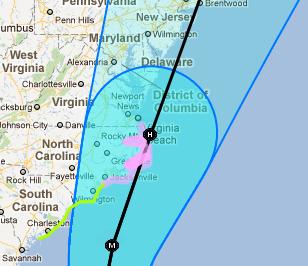
 Hurricane Irene is no joke, getting stronger and moving closer to the East Coast today.
The storm is expected to become a Category 4 storm that will churn it up seaboard and is expected to impact the Mid-Atlantic coast late Saturday into Sunday morning, bringing high winds to heavy rains to the coast.
For the Potomac Communities, well, the storm’s forecasted effects on us aren’t as clear.
Most of the winds and rain will impact areas to the west, but if the storm tracks to east just slightly the area could see substantially more wind and rainfall than what’s forecasted right now, according to NBCWashington.com Meteorologist Doug Kammerer.
The National Hurricane Center is also using Google Maps to track the storm and has compiled some information that’s worth checking out.
Officials in Stafford County say they are monitoring the hurricane and will set up shelters for residents to use if necessary. They’ve also encouraged residents to prepare for the coming storm by taking some precautions.
Citizens should begin preparing for an emergency before the emergency occurs. One of the easiest things to do is to organize an emergency supply kit for your family that will be able to sustain them for at least three days. The kit should include items such as non-perishable food, water, a battery power or hand-crank radio, extra flashlights and batteries. Citizens may want to purchase a dual power (electric with battery backup) NOAA weather radio. They are inexpensive and available at several stores in the area. They should also consider making their kit portable and keeping it in their car in case they have to evacuate.
Citizens should also take some time to prepare their homes for heavy rains and high winds. FEMA suggests the following:
• Plan to bring in all outdoor furniture, decorations, garbage cans and anything else that is not tied down.


