
If you weren’t sick enough of the cold and snow already – be prepared for more.
According to the National Weather Service, the Northern Virginia area will stay in the single digit temperatures throughout tonight.
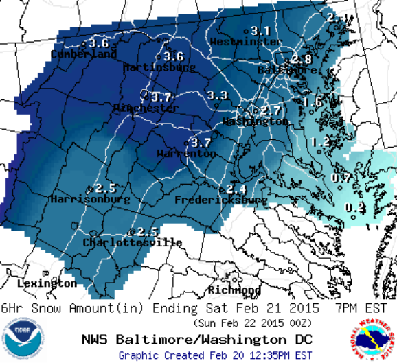
And on Saturday, a system is expected to move through the area, with snow and ice accumulation over three inches projected in some areas.
VDOT has already announced they are still plowing secondary areas from this week’s storm, and advised motorists to check conditions before getting on the road.
Potomac Local will continue to monitor the weather and provide you with all of the updates on closings, delays and outages.
More from a National Weather Service release:
THIS HAZARDOUS WEATHER OUTLOOK IS FOR EASTERN WEST VIRGINIA…
NORTHERN AND CENTRAL VIRGINIA…AND CENTRAL AND WESTERN MARYLAND
WITH THE EXCEPTION OF GARRETT COUNTY.
.DAY ONE…THIS AFTERNOON AND TONIGHT
WIND CHILLS WILL REMAIN IN THE SINGLE DIGITS ABOVE ZERO THROUGH
TONIGHT.
.DAYS TWO THROUGH SEVEN…SATURDAY THROUGH THURSDAYA LOW PRESSURE SYSTEM WILL LIKELY BRING ACCUMULATING SNOW AND ICE
TO THE AREA SATURDAY INTO SATURDAY NIGHT BEFORE PRECIPITATION
CHANGES TO RAIN BY SUNDAY. A WINTER STORM WATCH HAS BEEN ISSUED
FOR NORTH-CENTRAL MARYLAND…NORTHERN AND CENTRAL VIRGINIA…AND
FOR ALL LOCATIONS ALONG AND WEST OF THE BLUE RIDGE MOUNTAINS
SATURDAY AND SATURDAY NIGHT. MONITOR LATER FORECASTS FOR
UPDATES… AS UNCERTAINTY REMAINS WITH THE TIMING AND IMPACTS FROM
THIS SYSTEM.