
Due to Tropical Storm Isaias’ threat to our area, a Tropical Storm Watch has been issued for counties along the I-95 corridor and east. Flash Flooding will likely be our biggest impact Mon eve – Tue eve. Tidal/coastal flooding (Tue and Tue eve) is also a concern. Stay informed. pic.twitter.com/ClQOF1a9Oi
— NWS Baltimore-Washington (@NWS_BaltWash) August 2, 2020
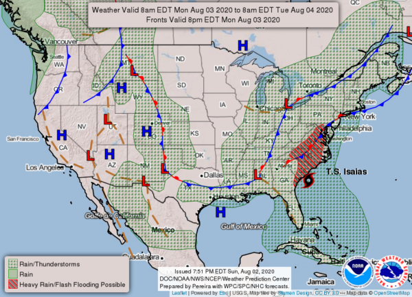
National Weather Service forecast:
Monday
A chance of showers and thunderstorms, then showers likely and possibly a thunderstorm after 3 pm. Mostly cloudy, with a high near 88. South wind 3 to 6 mph. Chance of precipitation is 60%. New rainfall amounts between a tenth and quarter of an inch, except higher amounts possible in thunderstorms.
Monday Night
Showers and thunderstorms likely, then showers and possibly a thunderstorm after midnight. Some of the storms could produce heavy rain. Low around 69. South wind around 7 mph. Chance of precipitation is 90%. New rainfall amounts between three quarters and one inch possible.
Tuesday
Tropical storm conditions possible. Showers and possibly a thunderstorm. Some of the storms could produce heavy rainfall. High near 82. Chance of precipitation is 90%. New rainfall amounts between 2 and 3 inches possible.
Tuesday Night
A chance of showers and thunderstorms before 2 am, then a slight chance of showers. Mostly cloudy, with a low around 68. Southwest wind 3 to 8 mph. Chance of precipitation is 40%.
Wednesday
A slight chance of showers before 8 am, then a chance of showers and thunderstorms after 2 pm. Mostly sunny, with a high near 89. Chance of precipitation is 30%.
Wednesday Night
A chance of showers and thunderstorms before 8 pm. Partly cloudy, with a low around 67. Chance of precipitation is 30%.
Thursday
A chance of showers and thunderstorms. Mostly sunny, with a high near 87. Chance of precipitation is 40%.
