
The region will once again find itself under a winter storm watch late Tuesday into Wednesday morning as a storm has our region in its sights.
Snow will move into the region from the southwest to the northeast Tuesday night, with an all-snow event impacting our area by Wednesday morning.
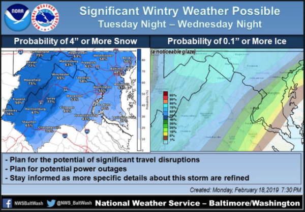
About four to eight inches of snow is expected during the storm. And, there will be ice to contend with, too, as warm air pushes into the region during the midday hours changing the snow to sleet and rain in some areas.
“Overall expect the warm air aloft to be a bit stronger than earlier guidance suggested, so cut snow amounts a bit, while increasing ice amounts a bit, but there are still details to be worked out… Either way, however, expect an impactful winter storm,” states the National Weather Service Washington, D.C. Forecast Office.
Despite sunny skies, colder air and gusty winds began moving into the region on Monday. The winds will subside Tuesday, but clouds will build into the area during the day with nighttime temperatures in the 20s, according to the weather service.
During the day Wednesday, temperatures are expected to rise into the 30s. Areas northwest of Interstate 95 won’t see temperatures above the freezing mark, but areas south and east are supposed to be a bit warmer.
The wintry precipitation could linger into Thursday afternoon, with a wintry mix possible on Thursday morning. Temperatures are expected to remain above freezing on Thursday, according to the weather service.
We’ll post weather-related delays and closings on our Twitter page, as usual. We always appreciate you Tweet using your snow photos.
