
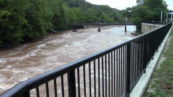
OCCOQUAN — Water rolled down the Occoquan River on Monday.
The heavy rains over the weekend created whitecap conditions on the river. Much of it could be seen by those viewing river form the Town of Occoquan’s River Mill Park.
Many came to the park to photograph the raging waters, which roared even louder the day before.
“If you saw it today, it’s pretty calm compared to Sunday when the water was rolling over the dams,” said Occoquan Mayor Earnie Porta.
Two dams just upriver from the town, known as the “small” and ‘’big” dams, hold back the water to create the Occoquan Reservoir, a source for drinking water in eastern Prince William and Fairfax counties.
They have no flood controls, added Porta. Even further upstream is the Lake Jackson Dam, which can be seen from Route 234 south of Manassas. Prince William County officials spent much of the weekend monitoring the dam and releasing water from it, as that dam does have built-in flood controls.
“Officials with Fairfax Water have told me that the distance between the town and the Lake Jackson Dam is so far, if something were to happen, the water would most likely spread out before it reached the town,” added Porta.
In town, some water topped the town’s boardwalk near the popular Bar-J Chili Parlor, but so far, the small shops and restaurants in the town have been spared from flooding.
The rain is expected to continue throughout the week, and Porta says that means those in the town will be on alert.
Aside from the river, town officials also monitor the Ballywhack Creek which flows into the town down Tanyard Hill from Lake Ridge. Water from heavy rains flushed down the creek flooding the town in 2011 during Tropical Storm Lee.
Porta said it’s important to keep clean a culvert where water from the creek flows. If the culvert is blocked with debris — in most cases large rocks — water can flow over the culvert causing flooding.
Here’s a video of water flowing into that culvert:
The National Weather Service has the region under a flash flood watch through late Tuesday night. Showers and thunderstorms, some with torrential rainfall are expected to impact the area again Tuesday, and with a ground that’s so saturated with water, flooding conditions could develop quickly, according to the weather service.
Flash Flood Watch extended until 2 AM Wednesday morning. Repetitive rounds of heavy rain may cause flash flooding. pic.twitter.com/S6CDg8kjVt
— NWS DC/Baltimore (@NWS_BaltWash) July 23, 2018
High temperatures will climb to 80 degrees on Tuesday, and 83 on Wednesday. Heavy rain is expected both days. Thursday’s forecast includes more thunderstorms, while
showers are in the forecast for Friday and the weekend.
