
We’re in for some potentially dangerous weather this week, starting tonight with a line of thunderstorms that could bring damaging winds to the region.
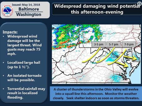
Numerous severe thunderstorms will be crossing the Mid Atlantic this afternoon-evening. Wind gusts 65-75 mph possible. Take precautions now for potential wind damage. If you hear thunder, seek safety indoors. pic.twitter.com/4PKi9V08lH
— NWS DC/Baltimore (@NWS_BaltWash) May 14, 2018
Later in the week, we have the possibility of flooding, according to the National Weather Service Forecasters Discussion page:
“The Thu night-Fri period looks like the wettest period of the week particularly late Thu night into Fri morning. Widespread amounts of 1 to 2 inches appear likely during this period. 13/18Z MMEFS guidance show potential for river flooding …. Given all the ingredients described above and increasingly wetter soils, some flooding appears likely this week, but location and timing are still uncertain. It does appear though as the I-95 corridor would be the most vulnerable to flooding.”