
Update
It looks like the area will be seeing some more stormy and hot weather.
According to the National Weather Service, scattered and severe thunderstorms are possible this afternoon and evening.
There may also be damaging winds and large hail. Additionally, there could be thunderstorms with significant rainfall and flash flooding.
Along with the stormy weather, the National Weather service has announced a heat advisory for the entire Interstate 95 corridor.
It is expected that the temperature will rise to 105 degrees.
The advisory is in effect from 1 p.m. to 7 p.m.
More from the National Weather Service:
A HEAT ADVISORY MEANS THAT A PERIOD OF HIGH TEMPERATURES IS EXPECTED. THE COMBINATION OF HIGH TEMPERATURES AND HIGH HUMIDITY WILL CREATE A SITUATION IN WHICH HEAT ILLNESSES ARE POSSIBLE.
TAKE EXTRA PRECAUTIONS IF YOU WORK OR SPEND TIME OUTSIDE. WHEN POSSIBLE…RESCHEDULE STRENUOUS ACTIVITIES TO EARLY MORNING OR EVENING. KNOW THE SIGNS AND SYMPTOMS OF HEAT EXHAUSTION AND HEAT
STROKE. WEAR LIGHT WEIGHT AND LOOSE FITTING CLOTHING WHEN POSSIBLE AND DRINK PLENTY OF WATER.
TO REDUCE RISK DURING OUTDOOR WORK…THE OCCUPATIONAL SAFETY AND HEALTH ADMINISTRATION RECOMMENDS SCHEDULING FREQUENT REST BREAKS
IN SHADED OR AIR CONDITIONED ENVIRONMENTS. ANYONE OVERCOME BY HEAT SHOULD BE MOVED TO A COOL AND SHADED LOCATION. HEAT STROKEIS AN EMERGENCY – CALL 911.
Original post
Sweltering hot temperatures and more potentially dangerous storms are in the forecast.
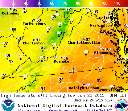
We’ll see a high of 96 degrees on Tuesday. Factor in the heat index, and we could be looking at temperatures that feel like 101 or better.
The hot temperatures could also bring severe thunderstorms much like we saw on Saturday night, said National Weather Service Baltimore-Washington office forecaster James Lee.
According to the weather service, the movement of a cold front across the region could determine when we could see some nasty weather. The storms could come during the afternoon or evening, so keep an umbrella handy for the drive home from work on Tuesday.
This latest threat of stormy weather comes days after a massive line a damaging, potentially tornado-causing weather moved through the region Saturday night. That storm — remnants of Tropical Storm Bill that slammed into Texas last week — caused flooding, topped trees and structures, and lightning from the storms sparked several house fires.
We are well into the summer season now, and the weather pattern setting up for the remainder of the week reflects the season.
While not nearly as hot as Tuesday’s forecasted temperatures in the high 90s, the rest of the week will bring temps in the high 80s, as well as more chances for thunderstorms on Thursday and Friday.
Your weekend should be warm with highs in the low 80s, with a chance of showers on Saturday and Sunday.