

5:53p.m.
The Stafford County Fire and Rescue Department were called to the scene of another collision, at Shelton Shop and Courthouse Road. According to the department, one of the individuals in the crash was injured.
RE-14 on the scene with 2 vehicles head on 1 lane block and 1 injured.
— Stafford County FR (@SCFR) March 1, 2015
Units responding to a 2 vehicle accident reported head on in the area of Shelton Shop and Courthouse Rd.
— Stafford County FR (@SCFR) March 1, 2015
1:05 p.m.
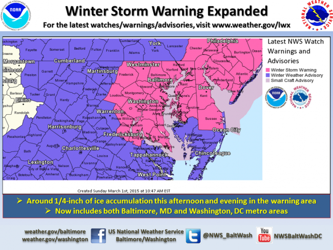
A winter storm warning is in effect for Prnce William and Stafford counties, and the cities of Manassas and Manassas Park until 3 a.m. Monday.
Here’s the latest from the National Weather Service:
THE NATIONAL WEATHER SERVICE IN BALTIMORE MD/WASHINGTON HAS
ISSUED A WINTER STORM WARNING FOR FREEZING RAIN…WHICH IS IN
EFFECT UNTIL 3 AM EST MONDAY. THE WINTER WEATHER ADVISORY IS NO
LONGER IN EFFECT.* LOCATIONS…WASHINGTON METROPOLITAN AREA…CENTRAL AND SOUTHERN
MARYLAND.* HAZARD TYPES…SNOW…SLEET…AND FREEZING RAIN.
* ACCUMULATIONS…A COATING TO AN INCH OF SNOW AND SLEET. 1 TO 2
INCHES OF SNOW AND SLEET NEAR THE MASON-DIXON LINE. ICE
ACCUMULATION AROUND ONE QUARTER INCH.* TIMING…SNOW AND SLEET WILL CHANGE TO FREEZING RAIN BETWEEN 11
AM AND 1 PM THIS AFTERNOON. THE HEAVIEST ICE ACCRETION FROM FROM
FREEZING RAIN IS EXPECTED THIS AFTERNOON AND EARLY EVENING.
PRECIPITATION WILL END THIS EVENING.* IMPACTS…ROADS WILL BE SNOW AND ICE COVERED THROUGH TONIGHT.
TRAVELLING WILL BE DANGEROUS.* WINDS…SOUTH AROUND 5 TO 10 MPH.
* TEMPERATURES…RISING THROUGH THE 20S THIS AFTERNOON.
TEMPERATURES WILL RISE INTO THE LOWER 30S
1 p.m.
@icyroadsafety @VaDOTFRED @VaDOTNOVA @PotomacLocal & #ScrapeThatIce pic.twitter.com/IVxP5LmHFd
— ABC Driving Clinic (@ABC_Driver) March 1, 2015
12:25p.m.
Earlier today, the Stafford County Fire and Rescue Department responded to the scene of an auto accident on Kellogg Mill Road in Stafford.
There were reports of lines down on the car, according to a tweet from the fire and rescue department.
According to Mark Doyle, Assistant Chief for the department, the scene has been clear and no one was injured.
While he couldn’t confirm, Doyle stated he believed the cause of the accident was most likely weather related.
Fire Rescue units are responding to an auto accident at 841 Kellogg Mill Rd. Reports of lines down on the vehicle.
— Stafford County FR (@SCFR) March 1, 2015
11:15a.m.
Crews rolling but steady sleet/freezing rain across region. Stay off roads if you can–expect conditions to deteriorate through the day.
— VDOT Northern VA (@VaDOTNOVA) March 1, 2015
9a.m.
The National Weather Service has issued a Winter Weather advisory for the area, in effect this morning until 3a.m. on Monday.
An accumulation of inch of snow and sleet is expected.
Potomac Local will keep you updated on the latest in closings, delays and outages.
More from a National Weather Service alert:
…WINTER WEATHER ADVISORY REMAINS IN EFFECT FROM 7 AM THIS
MORNING TO 3 AM EST MONDAY..
* LOCATIONS…WASHINGTON METROPOLITAN AREA AND SOUTHERN MARYLAND.
* HAZARD TYPES…SNOW…SLEET…AND FREEZING RAIN.
* ACCUMULATIONS…A COATING TO 1 INCH OF SNOW AND SLEET ACROSS
WASHINGTON DC AND SOUTHERN MARYLAND. 1 TO 2 INCHES IN THE
NORTHERN AND WESTERN SUBURBS OF WASHINGTON DC. ICE
ACCUMULATION AROUND ONE TENTH OF AN INCH.
* TIMING…SNOW WILL BEGIN BETWEEN 7 AM AND 10 AM THIS MORNING.
SNOW WILL CHANGE TO SLEET AND FREEZING RAIN BETWEEN NOON AND 3
PM THIS AFTERNOON. PRECIPITATION WILL END AS FREEZING RAIN TONIGHT.
* IMPACTS…ROADS WILL BE SNOW AND ICE COVERED TODAY AND TONIGHT.
TRAVELLING WILL BE DIFFICULT WITH REDUCED VISIBILITIES FROM SNOW
AND SLICK ROADWAYS.
* WINDS…SOUTH AROUND 5 TO 10 MPH.
* TEMPERATURES…RISING THROUGH THE 20S MORNING. TEMPERATURES WILL
RISE INTO THE LOWER AND MIDDLE 30S THIS AFTERNOON BEFORE
DROPPING BACK INTO THE LOWER 30S LATE TONIGHT.
PRECAUTIONARY/PREPAREDNESS ACTIONS…
A WINTER WEATHER ADVISORY MEANS THAT PERIODS OF SNOW…SLEET…OR
FREEZING RAIN WILL CAUSE TRAVEL DIFFICULTIES. BE PREPARED FOR
SLIPPERY ROADS AND LIMITED VISIBILITIES…AND USE CAUTION WHILE
DRIVING.