
Updated
A wind chill advisory that was supposed to end at 9 a.m. Friday will be extended until noon. And even then there’s no immediate signs of the cold letting up.
Here are the chilling details from the National Weather Service:
A wind chill advisory that was supposed to end at 9 a.m. Friday will be extended until noon. And even then there’s no immediate signs of the cold letting up.
Here are the chilling details from the National Weather Service:
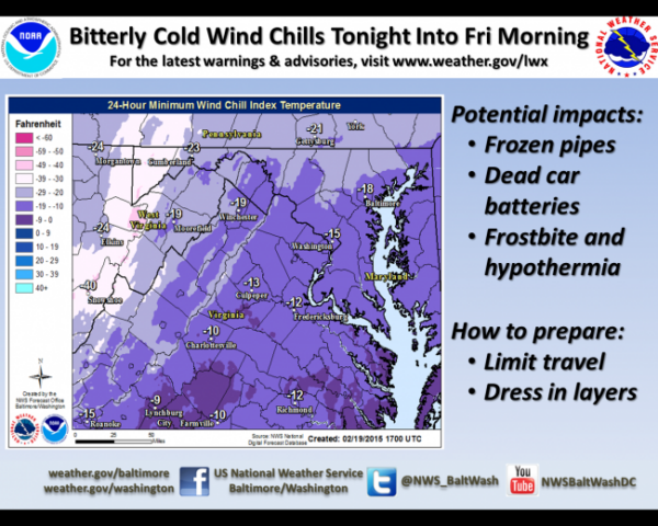
…WIND CHILL ADVISORY NOW IN EFFECT UNTIL NOON EST FRIDAY…* WIND CHILL…BETWEEN ZERO AND 10 BELOW INTO THE EVENING HOURS
BEFORE FALLING TONIGHT TO AROUND 10 TO 15 DEGREES BELOW ZERO.* TEMPERATURES…DROPPING INTO THE LOWER AND MIDDLE TEENS THIS
EVENING. LOWS TONIGHT INTO EARLY FRIDAY AROUND ZERO.* WINDS…WEST 15 TO 20 MPH WITH GUSTS AROUND 30 TO 35 MPH INTO
THIS EVENING…SUBSIDING TO 10 TO 20 MPH OVERNIGHT AND INTO LATE
MORNING FRIDAY.* IMPACTS…THE COMBINATION OF GUSTY WINDS AND COLD TEMPERATURES
MAY RESULT IN DANGEROUS WIND CHILLS THAT CAN QUICKLY CAUSE
HYPOTHERMIA AND FROST BITE.PRECAUTIONARY/PREPAREDNESS ACTIONS…
Here’s the forecast for the rest of the week.
Original post
Yeah, it’s cold outside. The National Weather Service posted the unofficial wind chill low temperatures in the region taken during the overnight hours.
Take a look:
| Location | Wind chill degree Fahrenheit | Time |
QUANTICO MARINE CORP BASE |
-5.0 |
6:56 a.m. |
PRINCE WILLIAM COUNTY -- Independent Hill |
-7.0 |
7:10 a.m. |
STAFFORD COUNTY |
-5.0 |
7 a.m. |
DULLES INTERNATIONAL |
-9.0 |
5:52 a.m. |
TYSONS CORNER |
-5.0 | 6:50 a.m. |
All of this cold weather isn’t going anywhere, either. Here’s the latest forecast:
…WIND CHILL ADVISORY REMAINS IN EFFECT UNTIL 10 AM EST FRIDAY…
* WIND CHILL…0 TO 10 DEGREES BELOW ZERO THIS MORNING. WIND
CHILLS MAY RISE CLOSER TO ZERO THIS AFTERNOON BEFORE FALLING
TONIGHT TO AROUND 10 TO 15 DEGREES BELOW ZERO.* TEMPERATURES…HIGHS TODAY IN THE TEENS. LOWS TONIGHT INTO EARLY
FRIDAY AROUND ZERO.* WINDS…WEST 15 TO 20 MPH WITH GUSTS AROUND 30 TO 35 MPH INTO
THIS EVENING…SUBSIDING TO 10 TO 20 MPH OVERNIGHT.* IMPACTS…THE COMBINATION OF GUSTY WINDS AND COLD TEMPERATURES
MAY RESULT IN DANGEROUS WIND CHILLS THAT CAN QUICKLY CAUSE
HYPOTHERMIA AND FROST BITE.PRECAUTIONARY/PREPAREDNESS ACTIONS…
A WIND CHILL ADVISORY MEANS THAT VERY COLD AIR AND STRONG WINDS
WILL COMBINE TO GENERATE LOW WIND CHILLS. THIS WILL RESULT IN
FROST BITE AND LEAD TO HYPOTHERMIA IF PRECAUTIONS ARE NOT TAKEN.
IF YOU MUST VENTURE OUTDOORS…MAKE SURE YOU WEAR A HAT AND
GLOVES.