
Residents of the Mid-Atlantic, it’s our turn.
Snow is headed our way, and this storm is shaping up to bring us the most significant winter precipitation this season. After some near misses, and after portions of the northeast has seen as much as seven feet of snow, snow lovers in our area will take delight in a forecast that calls for accumulations of more than six inches.
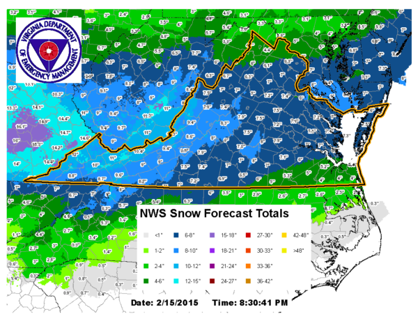
Here’s more in a press release from the National Weather Service:
…WIND CHILL ADVISORY REMAINS IN EFFECT UNTIL 10 AM EST THIS
MORNING…
…WINTER STORM WARNING REMAINS IN EFFECT FROM 4 PM THIS
AFTERNOON TO NOON EST TUESDAY…* PRECIPITATION TYPE…SNOW.
* ACCUMULATIONS…6 TO 10 INCHES.
* TIMING…SNOW IS EXPECTED TO DEVELOP LATE THIS AFTERNOON AND
CONTINUE INTO TUESDAY MORNING. HEAVIEST SNOW IS EXPECTED THROUGH
TONIGHT.* WIND CHILL…AS LOW AS 10 BELOW.
* TEMPERATURES…4 TO 25 ABOVE.
* WINDS…NORTHEAST 5 TO 10 MPH WITH GUSTS UP TO 20 MPH.
* IMPACTS…THE COMBINATION OF GUSTY WINDS AND COLD TEMPERATURES
WILL CONTINUE TO MAKE DANGEROUS WIND CHILLS THAT CAN QUICKLY
CAUSE HYPOTHERMIA AND FROST BITE THROUGH THIS MORNING. BEGINNING
LATE THIS AFTERNOON…ROADS WILL BECOME SNOW COVERED AND
SLIPPERY WITH VISIBILITIES BEING REDUCED TO ONE HALF MILE OR
LESS AT TIMES. THE COMBINATION OF SNOW COVERED ROADS AND LOW
VISIBILITY WILL MAKE TRAVELING DANGEROUS.PRECAUTIONARY/PREPAREDNESS ACTIONS…
A WINTER STORM WARNING FOR HEAVY SNOW MEANS SEVERE WINTER WEATHER
CONDITIONS ARE EXPECTED OR OCCURRING. SIGNIFICANT AMOUNTS OF SNOW
ARE FORECAST THAT WILL MAKE TRAVEL DANGEROUS. ONLY TRAVEL IN AN
EMERGENCY. IF YOU MUST TRAVEL…KEEP AN EXTRA FLASHLIGHT…
FOOD…AND WATER IN YOUR VEHICLE IN CASE OF AN EMERGENCY.A WIND CHILL ADVISORY MEANS THAT VERY COLD AIR AND STRONG WINDS
WILL COMBINE TO GENERATE LOW WIND CHILLS. THIS WILL RESULT IN
FROST BITE AND LEAD TO HYPOTHERMIA IF PRECAUTIONS ARE NOT TAKEN.
IF YOU MUST VENTURE OUTDOORS…MAKE SURE YOU WEAR A HAT AND
GLOVES.
Forecasters at the National Weather Service office in Sterling say snow is the only precipitation type they are concerned about with this approaching storm. That is a departure from normal when we often see a mixed bag of precipitation during winter storms like snow, sleet, freezing rain, and rain.