
From the National Weather Service:
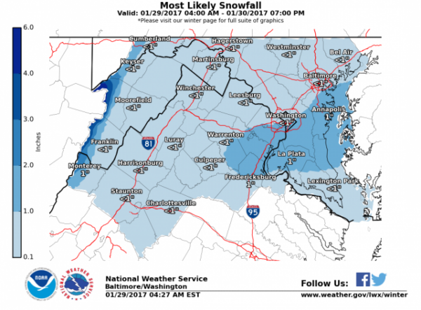
“The most likely scenario is for most locations to receive a coating to an inch of snow…but a thin band of 1-3” is possible where the banding precipitation does setup. Will assess the new guidance this afternoon before making a decision on headlines.
The snow should be moving out between 4 and 6 am across most areas…but temps will continue to fall below freezing. Therefore…any wet or slushy roads may freeze during the morning rush causing treacherous travel conditions.”
“THIS HAZARDOUS WEATHER OUTLOOK IS FOR THE MARYLAND PORTION OF THE CHESAPEAKE BAY, TIDAL POTOMAC RIVER, AND ADJACENT COUNTIES IN CENTRAL MARYLAND AND NORTHERN VIRGINIA AS WELL AS THE DISTRICT OF COLUMBIA. .DAY ONE…TODAY AND TONIGHT ACCUMULATING SNOW IS LIKELY ACROSS THE OUTLOOK AREA TONIGHT…”
From VDOT:
“Drivers in northern Virginia are asked to monitor forecasts and plan for snow showers to impact tomorrow morning’s commute.
Please watch for slow-moving trucks today as they pretreat roads through the region. Crews will spray brine on interstates and main roads to help prevent snow from sticking when it begins to fall overnight.
Tonight, crews will load materials and stage roadside by 10 p.m. They will remain on duty through Monday to treat roads with salt and sand as needed, as pavement temperatures are expected to be near freezing.
Drivers are asked to:
· Monitor weather forecasts closely, as storm timing and intensity can always change.
· Check weather and road conditions before leaving, and adjust commutes or allow additional travel time.
· Reduce speeds; use headlights; do not overdrive conditions.”
Update
WINTER WEATHER ADVISORY REMAINS IN EFFECT FROM 10 PM THIS
EVENING TO 7 AM EST MONDAY…* PRECIPITATION TYPE…SNOW.
* ACCUMULATIONS…A COATING TO 1 INCH NORTH OF INTERSTATE 66 IN
VIRGINIA AND NORTH OF US ROUTE 50 IN MARYLAND. 1 TO 2 INCHES ARE
EXPECTED SOUTH OF INTERSTATE 66 IN VIRGINIA AND SOUTH OF US
ROUTE 50 IN MARYLAND.* TIMING…SNOW WILL OVERSPREAD THE AREA BETWEEN 8 AND 11 PM THIS
EVENING. THE STEADIEST SNOW IS EXPECTED BETWEEN 11 PM AND 4 AM.
SNOW WILL END BY 6 AM ACROSS MOST LOCATIONS.* IMPACTS…ROADS WILL BE MAINLY WET THIS EVENING WITH
TEMPERATURES ABOVE FREEZING. UNTREATED SURFACES WILL BECOME
SLIPPERY AFTER MIDNIGHT WITH TEMPERATURES DROPPING TO NEAR OR
SLIGHTLY BELOW FREEZING* WINDS…NORTH TO NORTHWEST AROUND 5 MPH…BECOMING NORTHWEST
AROUND 10 TO 15 MPH TOWARD MORNING.* TEMPERATURES…MID TO UPPER 30S THIS EVENING…FALLING INTO THE
UPPER 20S AND LOWER 30S OVERNIGHT INTO EARLY MONDAY MORNING.PRECAUTIONARY/PREPAREDNESS ACTIONS…