
 Today’s weather forecast is sponsored by Water’s End Brewery. Sometimes all you need is a Damn Beer. Take 96oz of this crisp, Golden Ale brewed fresh by Water’s End Brewery to-go with you in a 6-Pounder for just $14.99!
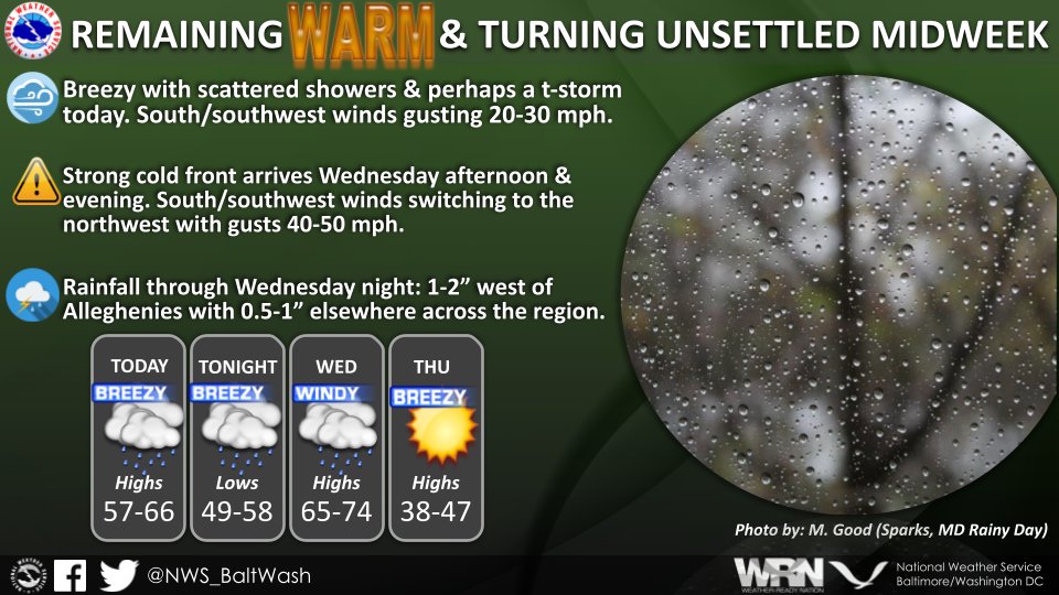
A day of dynamic weather lies ahead as a low-pressure system barrels into the region, promising scattered showers and unseasonably mild temperatures.
The National Weather Service alerts that a low-pressure system from the Midwest, accompanied by a warm front, is set to sweep through the area, triggering scattered showers and potential thunderstorms. The system is expected to bring scattered showers starting late morning, mainly north of I-66 and US-50, with precipitation becoming more widespread across the area by early afternoon. While the risk of thunderstorms remains low for the day, gusty winds ranging from 25 to 30 mph are anticipated, adding to the atmospheric turbulence.
Overnight, although there might be a temporary lull in precipitation, the warm front lifting through the region could reignite scattered showers, mainly north of the Mason-Dixon line and across the Appalachian Mountains. There’s even a slight chance of thunderstorms accompanying these showers, contributing to the unsettled weather pattern.
Remarkably mild temperatures for late February are forecasted, with overnight lows hovering in the mid-50s, a staggering 25 degrees above normal. Gusty southerly winds will accompany these warm temperatures, further enhancing the sense of a strange weather event.
Looking ahead, Wednesday is poised to bring more weather disruptions, with showers likely and the possibility of thunderstorms, mainly after 1 p.m. Temperatures are expected to soar to about 74 degrees, maintaining the unseasonably warm trend. However, a cold front is anticipated to pass through the region Wednesday night, bringing cooler temperatures on Thursday as dry high-pressure returns.