
 Today’s weather forecast is sponsored by Water’s End Brewery. Sometimes all you need is a Damn Beer. Take 96oz of this crisp, Golden Ale brewed fresh by Water’s End Brewery to-go with you in a 6-Pounder for just $14.99!
A frontal system is expected to bring unsettled weather conditions through this afternoon, according to the National Weather Service. Temperatures range from the mid-40s to low 50s in this area, while cooler temperatures in the mid-30s to low 40s prevail to the north, accompanied by patchy fog due to trapped moisture and light winds.
As the day progresses, an upstream cold front will move through the area, resulting in west-northwesterly winds that should dissipate any lingering fog. Some shower development is possible from I-95 eastward during the late morning to mid-afternoon hours, with temperatures remaining mild in the mid to upper 50s. However, cooler temperatures are expected over higher terrain and northeastern Maryland, with highs in the low 50s and 40s, respectively. Gusts up to 25 to 30 mph are possible in mountainous areas.
Heading into the evening, showers are forecasted, continuing overnight over the Alleghenies. Colder air arriving at night may lead to light snow accumulations, primarily in mountainous regions, with lows generally in the 30s for most of the area and mid to upper 20s along the Allegheny Front.
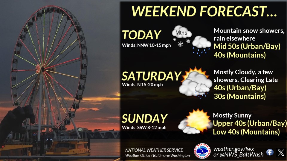
Weekend Outlook: Chilly Start with Tranquil Conditions
On Saturday, the favorable upslope flow will persist, bringing additional light snow to the Alleghenies, with storm total snow amounts likely ranging from a trace to an inch. A shortwave trough tracking from the lower Ohio Valley to the Carolinas may spread light to moderate precipitation across the Potomac Highlands toward I-64, with 1 to 2 inches of snow expected over the central Blue Ridge.
Chilly conditions will prevail throughout the day, with temperatures largely in the 40s and north-northwesterly winds gusting up to 20 to 25 mph. Skies will be mostly cloudy, though some sunshine is possible late in the day.
Sunday will see tranquil conditions as high pressure builds, bringing more sunshine to the area. Southerly winds will lead to milder temperatures, especially west of the Blue Ridge and Catoctin Mountains, with highs around 5 to 10 degrees above Saturday’s temperatures. Clouds will increase later in the evening ahead of the next cold front, with some light precipitation possible in the Alleghenies, mainly as snow for the highest ridgetops. Lows will be in the 30s across the area.
Overall, residents can expect a mix of precipitation and mild temperatures today, followed by a chilly start to the weekend with improving conditions and milder temperatures by Sunday.