
A stretch of dangerous heat will grip the region Wednesday before strong storms move in on Thursday and usher in cooler weather for the weekend.
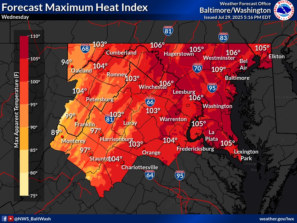
The National Weather Service has issued a Heat Advisory from 11 a.m. to 8 p.m. Wednesday for much of the D.C. metro area, including northern and central Virginia and parts of Maryland. Heat index values are expected to reach between 105 and 109 degrees, making it potentially hazardous for those spending extended time outdoors. Residents are urged to stay hydrated, remain in air-conditioned spaces when possible, and check on vulnerable neighbors and relatives.
By Thursday, a strong cold front will move into the region, bringing widespread showers and thunderstorms during the afternoon and evening. The primary concern is flash flooding, as storms will be slow-moving and capable of producing torrential rainfall of 1 to 2 inches in less than an hour. While the risk of severe storms is limited, local downpours and ponding on roads could lead to travel disruptions.
The front will clear the region Thursday night, paving the way for cooler and less humid conditions through the weekend.
Forecast Highlights:
- Wednesday: Heat Advisory in effect 11 a.m.–8 p.m. Highs in the mid to upper 90s with dangerous heat indices up to 109. Mostly sunny with a few evening storms possible west of the Blue Ridge.
- Thursday: Stormy and humid. Showers and thunderstorms are likely in the afternoon and evening. Flash flooding is possible. Highs in the low 90s with heat indices up to 105.
- Friday: Cooler and drier. Highs in the low to mid-80s under partly sunny skies.
- Saturday: Pleasant and sunny. Comfortable temperatures with highs in the low 80s.
- Sunday: Mild with a slight chance of showers. Highs near 80.