Join

Severe Weather Alert: Strong Storms and Gusty Winds Expected

According to the National Weather Service (NWS), a potent weather system is set to impact the region today, bringing strong storms and gusty winds.

A deepening area of low pressure and an associated cold front will move across the region Wednesday, ushering in a line of showers and thunderstorms. Some storms may become severe, followed by a prolonged period of strong winds from Wednesday night into Thursday afternoon.

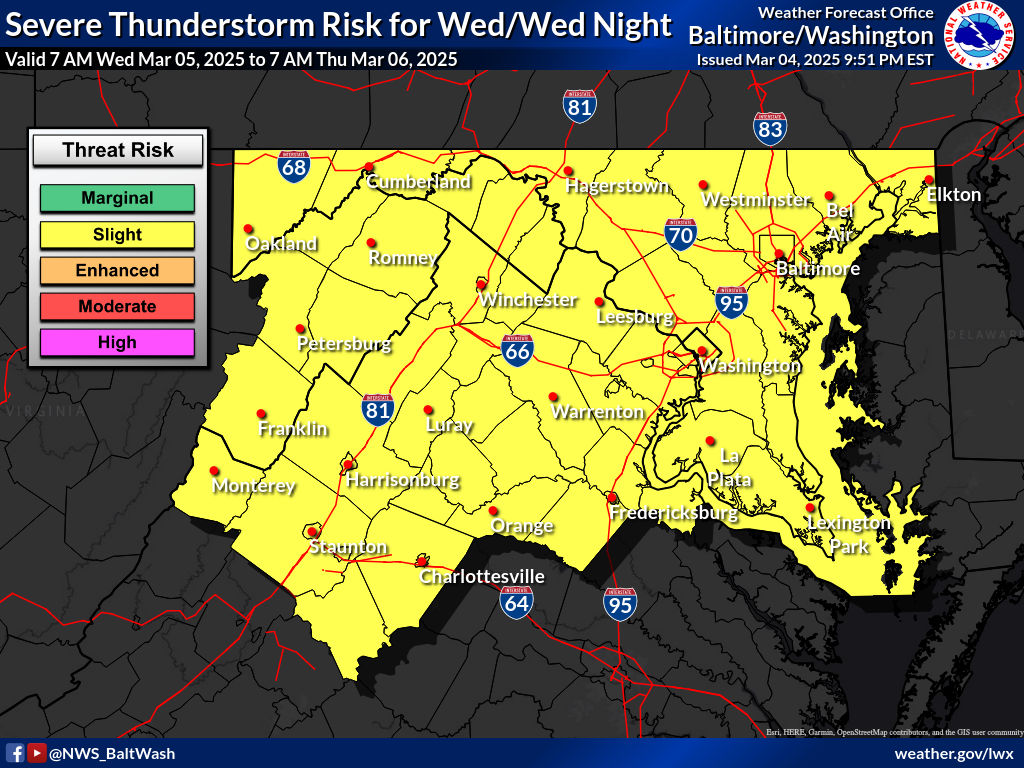
Severe Weather Timing and Potential Hazards
The NWS has adjusted its forecast to account for two rounds of potential severe weather on Wednesday. The first wave of storms is expected to arrive late Wednesday morning, primarily impacting areas along and west of the Blue Ridge between 11 a.m. and 1 p.m. The storms will then advance eastward toward metropolitan areas between noon and 4 p.m.

Meteorologists warn that damaging wind gusts will be the primary threat with this initial line of storms, with the possibility of isolated tornadoes embedded within the squall line. The second round of storms may develop later in the afternoon as a mid-level dry slot allows for renewed surface heating and instability. If additional storms do form, they could be supercellular in nature, posing risks of damaging winds, large hail, and a few tornadoes. The highest potential for these storms will be west of the Blue Ridge and along the Interstate 81 corridor.

Wind and Post-Storm Conditions
Gusty northwest winds will become the primary concern as the cold front clears the region late Wednesday night. Winds will strengthen throughout the area, with gusts reaching 30-50 mph, particularly on Thursday morning and afternoon. A Wind Advisory has already been issued for the higher elevations of the Alleghenies and the Blue Ridge, where gusts could reach 50 mph. Additional advisories may be required for other parts of the region.

Wintry Conditions in Higher Elevations
On the back side of the system, precipitation will linger over the mountains, transitioning to snow early Thursday. The western slopes of the Allegheny Front may see snow accumulations of 1-4 inches, which could cause hazardous travel conditions along the I-68 and US-219 corridors. Strong post-frontal winds will contribute to reduced visibility and blowing snow in these areas.

Looking Ahead
High pressure is expected to briefly build into the region on Friday, providing a break from weather before another low-pressure system and cold front move through on Saturday. As broad high pressure returns, more settled conditions are forecast for Sunday and into early next week.

Precautionary Measures
Residents are urged to stay informed and take precautions before the incoming weather system. Secure outdoor objects that strong winds could blow away, prepare for possible power outages, and remain weather-aware, especially if traveling in affected areas.

Recent Stories

WOODBRIDGE, Va. – Police say three men were injured in a shooting that broke out Wednesday afternoon, May 21, 2025, in a wooded area behind a busy shopping center on Smoketown Road.

STAFFORD, Va. – The FBI confirms it is reviewing the actions of one of its own agents who was involved in a fatal off-duty shooting in a Stafford County neighborhood earlier this year—and is now facing four criminal charges related to separate gun-related incidents.

MANASSAS, Va. – The City of Manassas is moving forward with plans for a new extended-stay hotel at the Landing at Cannon Branch. At a May 20, 2025, work session, the City Council reviewed architectural plans for a Home2 Suites by Hilton, a four-story, 100-room hotel that will become the second Hilton-branded property in the development.

STAFFORD, Va. – A surge of public opposition to large-scale data center development dominated the May 20, 2025, Stafford County Board of Supervisors meeting, leading county leaders to unanimously order a full review of the rules governing these rapidly expanding facilities.

POTOMAC, MD – A local credit union is receiving national recognition for offering some of the highest certificate rates in the country. Lafayette Federal Credit Union, headquartered in Rockville and serving the greater Washington, D.C. region, has been named by financial outlets including The Wall Street Journal, Kiplinger, Investopedia, DepositAccounts, and GoBankingRates for its top-ranked share certificate products.

According to these sources, Lafayette Federal currently holds the #1 national ranking for its 2-, 3-, 4-, and 5-year certificate terms. The institution is offering fixed annual percentage yields (APYs) up to 4.28%, with a minimum deposit requirement of $500.

Share certificates, also known as certificates of deposit (CDs) at traditional banks, have grown in popularity as a low-risk savings option during a period of economic uncertainty. With interest rates rising and market volatility continuing, many savers are seeking fixed returns on their funds without taking on additional risk.

Read More

Submit your own Community Post here.

Your Weight Matters National Convention

Hosted by the Obesity Action Coalition (OAC) since 2012, this highly-anticipated gathering is the nation’s leading gathering focused on empowering individuals with science-based education, support and practical tools for managing weight and improving health.

This unique Convention truly has something

Van Metre 5K Run

Participate in the 33rd Annual Van Metre 5K Run—a race that goes further than 3.1 miles, where every stride you take supports Children’s National Hospital. The Van Metre 5K Run donates 100% of proceeds to Children’s National Hospital and has

Ă—

Subscribe to our mailing list