
 Today’s weather forecast is sponsored by Water’s End Brewery. Sometimes all you need is a Damn Beer. Take 96oz of this crisp, Golden Ale brewed fresh by Water’s End Brewery to-go with you in a 6-Pounder for just $14.99!
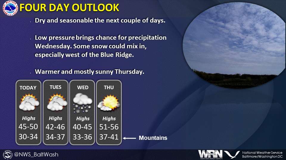
The weather forecast from the National Weather Service indicates that an upper-level trough is moving offshore, with another one expected by Tuesday night. Blustery northwest winds today will lead to wind chills in the 20s and 30s, along with broken cloud cover. Winds will diminish tonight, allowing temperatures to drop into the 20s to around freezing.
Dry weather is expected tonight into Tuesday, but clouds will increase during the day Tuesday as a clipper system approaches from the Great Lakes. The short-term forecast for Tuesday night through Wednesday night suggests a chance a mix of rain and snow, with light accumulations.
As the trough and associated low-pressure move offshore on Wednesday/Wednesday night, precipitation should shift southeastward and weaken. Lower elevations might see a mix with or change to rain on Wednesday, with relatively light amounts. Drying is anticipated Wednesday night, with temperatures falling into the 20s to around freezing, potentially causing freezing on untreated surfaces.
The detailed daily forecast:
- Today: Partly sunny with a high near 47, blustery northwest winds, and gusts up to 30 mph.
- Tonight: Partly cloudy with a low around 30, diminishing north winds, and gusts up to 20 mph.
- Tuesday: Partly sunny with a high near 45, light and variable wind becoming southeast 5 to 7 mph.
- Tuesday Night: A chance of rain and snow after 1 am, mostly cloudy with a low around 34, and a 30% chance of precipitation.
- Wednesday: A chance of rain and snow before 10 am, then a chance of rain between 10 am and 1 pm. Cloudy with a high near 44 and a 30% chance of precipitation. Light and variable wind becoming northeast around 6 mph in the morning.
