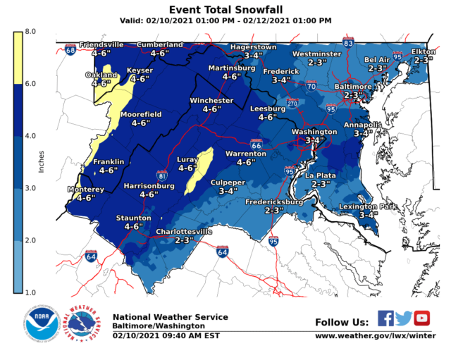
We should see much less snow than what was forecast to fall just 24 hours ago.
What had been five to eight inches of snow expected is now about two inches, according to the National Weather Service in Sterling. And for some — like Stafford County where a snow “hole” is forecast, there could be little to any accumulation.
This is not the snow-lovers forecast many had been hoping for. The weather service outlines a winter weather advisory, to include Prince William County, and the cities of Manassas and Manassas Park, in the update below.
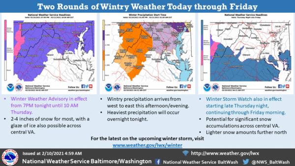
The storm is expected to move in after 5 p.m and stay with us through Friday.
…WINTER WEATHER ADVISORY REMAINS IN EFFECT FROM 7 PM THIS EVENING TO 10 AM EST THURSDAY…
…WINTER STORM WATCH REMAINS IN EFFECT FROM THURSDAY AFTERNOON THROUGH FRIDAY MORNING…
* WHAT…For the Winter Weather Advisory, mixed precipitation expected. Total snow accumulations of up to two inches and ice accumulations of a light glaze. For the Winter Storm Watch, heavy snow possible. Total snow accumulations of 5 to 7 inches possible.
* WHERE…Portions of central, northwest and western Virginia and eastern West Virginia.
* WHEN…For the Winter Weather Advisory, from 7 PM this evening to 10 AM EST Thursday. For the Winter Storm Watch, from Thursday afternoon through Friday morning.
* IMPACTS…Plan on slippery road conditions. The hazardous conditions could impact the morning or evening commute.
PRECAUTIONARY/PREPAREDNESS ACTIONS…
Slow down and use caution while traveling. Monitor the latest forecasts for updates on this situation.