
From the National Weather Service:
A cold front over central Pennsylvania will cross the Mid-Atlantic region late this morning… High pressure and cooler temperatures will return Thursday night and Friday.
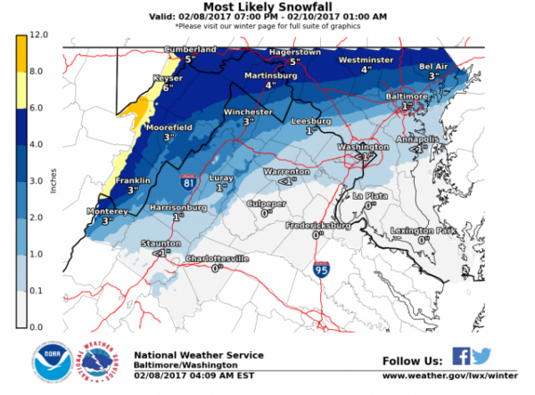
New winter weather headlines have been issued. Winter weather advisories for the northern tier counties and warning for the upslope areas. Overall, numerical model guidance have not changed much since yesterday afternoon. Low-level temps and especially road temps will be marginal for significant accumulations so undercut snow amounts some from models.
We currently have a winter storm watch in effect. I am not going to alter this but I feel the possiblity of 5″ is tenuous at best. North of the Mason-Dixon line – yes. But in addition to having marginal temperatures – and given the last two days the intial round of snowfall will melt on contact, AND the low will be moving rapidly off the coast making the time where snow can accumulate fairly short. The watch will likely be changed to advisories by mid morning, with the possibility of low-end warnings needing to be issued along the MD-PA border.
Updated 1:40 p.m.
From VDOT Fredericksburg
Snow showers may affect travel early Thursday morning in the Fredericksburg area, with potentially wet, slushy or snow-covered road conditions at the peak of the morning commute.
Virginia Department of Transportation (VDOT) crews have staff, trucks and materials ready to treat roads. Crews will mobilize before the morning rush hour period tomorrow, and will spread sand, salt and treatment chemicals as needed to improve motorist traction.
Drivers planning to travel Thursday morning are advised to allow extra travel time and be prepared to delay travel if road conditions become hazardous. Drivers are urged to check511Virginia before starting a trip.
Crews will monitor conditions in VDOT Park & Ride commuter lots and will treat and clear the lots as needed.
VDOT crews will begin plowing roads once two inches of snow has accumulated on the road surface.