
By ANGELA DAVENPORT
Long-range weather guidance indicates the potential for another coastal system (Nor’easter) the week of Thanksgiving.
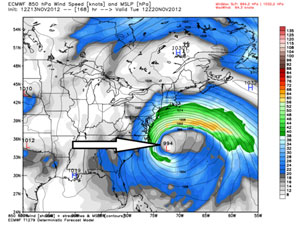
The latest models are showing an impressive system in the Mid-Atlantic building right off the coast on Nov. 20 or 21. There is question as to whether this system takes a westward turn and comes closer to the coast, stays out to sea, or favors a northern track and heads for New England.
Many different factors need to come together to set-up the support for this type of weather system. Nor’easters are rather unpredictable, which make it hard for meteorologists to provide forecasts until much closer to the actual event.
Meteorologists will not begin to make any sort of forecast or track analysis just yet, so this is strictly model discussion. But considering it’s such an important week with many holiday travelers, this is a potential system that should be closely monitored. Since temperatures are still relatively mild for November, this would bring varying types of precipitation (rain/snow/mix) based on where it lands.
If this was late December or January we’d be talking strictly snow, but it’s too early in the winter season for this to be an all-snow threat. Generally speaking, surface temperatures would not support accumulating (sticking) snow.
Meteorologists will keep a close eye on this one.
Angela Davenport lives in Woodbridge and keeps her eyes on the skies.