
 Today’s weather forecast is sponsored by Water’s End Brewery. Sometimes all you need is a Damn Beer. Take 96oz of this crisp, Golden Ale brewed fresh by Water’s End Brewery to-go with you in a 6-Pounder for just $14.99!
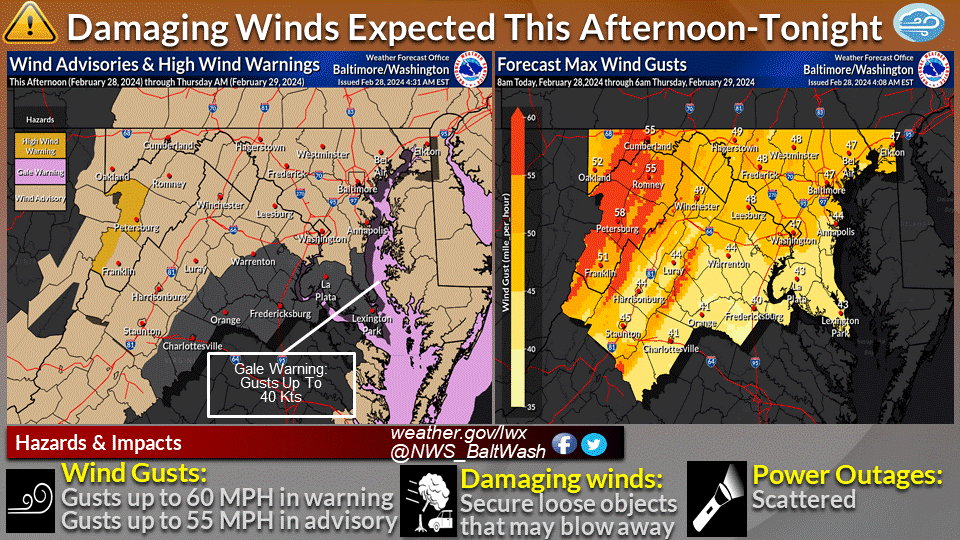
The National Weather Service issues alerts for widespread showers, gusty winds, and the possibility of thunderstorms later today. The forecast indicates that a robust cold front is set to sweep through the region, impacting various areas including northern Virginia and Maryland.
According to meteorologists, the front is expected to approach the area in the afternoon, with precipitation becoming more widespread as the day progresses. While the morning might see a few breaks in the clouds, conditions will rapidly change with the arrival of the front. Temperatures are forecasted to rise quickly into the mid to upper 60s, possibly hitting 70 degrees, before the front’s passage.
Anticipated wind patterns are also a cause for concern, as southerly winds are forecasted to increase to speeds of 10 to 15 mph, with gusts ranging from 25 to 35 mph during the morning into midday. The heaviest precipitation is expected later in the afternoon and evening, with forecasters predicting a window between 3 to 8 p.m. Thunderstorm probabilities are deemed low but not negligible, with a marginal risk for severe weather issued for certain areas.
In addition to the precipitation, the cold front’s passage will prompt a swift change in wind direction, shifting from southerly to northwesterly. This transition will bring about a shift in precipitation type, with rain showers switching to brief snow showers over mountainous regions. While snow accumulation is expected to be light, with only a coating to perhaps an inch, residents are urged to remain cautious, especially in elevated areas above 2500 feet.
As the night progresses into Thursday, winds are anticipated to intensify further, with gusts of 45 to 50 mph expected across the region. High elevations and mountain gaps may experience even stronger gusts, potentially nearing 60 mph, prompting the issuance of a High Wind Warning for certain areas. Wind advisories have been issued to cover the broader threat of strong winds, starting Wednesday evening and extending into early Thursday morning.