
A major winter storm forecast for late Saturday into Sunday is shifting toward a greater ice threat for Prince William County, Manassas, Manassas Park, Stafford County, and surrounding areas.
Key Takeaways
- When and where: Saturday afternoon through Sunday night across Prince William County, Manassas, Manassas Park, Stafford County, Fredericksburg, and nearby communities.
- What happened: Forecast updates show increased precipitation amounts and a higher likelihood of sleet and freezing rain mixing with snow.
- Why it matters: Ice accumulation could worsen travel conditions and increase the risk of power outages during extreme cold.
- Who drove the news: The National Weather Service Baltimore/Washington office.
Full Coverage
The National Weather Service says confidence remains high for a major winter storm across Northern Virginia and the Potomac region late Saturday into Sunday, but forecasters are increasingly concerned about ice.
Winter Storm Watches remain in effect from Saturday afternoon through Sunday night, while Cold Weather Advisories are in place beginning Friday evening. Updated forecasts increased liquid equivalent precipitation amounts by roughly one-third to one-half of an inch across much of the region.
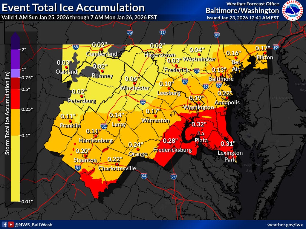
As precipitation totals increased, forecasters also adjusted expected snowfall amounts downward slightly. This change reflects a stronger signal for sleet and freezing rain, especially from central Virginia into southern Maryland and along parts of the Interstate 95 corridor.
Forecasters say a layer of warmer air several thousand feet above the ground is expected to move into the region Sunday. While surface temperatures will remain below freezing, this warm layer could cause snow to change to sleet or freezing rain, leading to ice accumulation on roads, trees, and power lines.
Ice accumulations have been increased by a few hundredths of an inch to as much as a tenth of an inch in areas most likely to see freezing rain. While snowfall could still be heavy at times, especially Saturday night, ice is now expected to play a larger role in impacts across Prince William County and Stafford County.
The National Weather Service says travel may become difficult or impossible during the peak of the storm. The combination of snow, ice, and prolonged cold temperatures increases the risk of power outages and hazardous conditions.
Behind the storm, frigid air is expected to settle into the region through much of next week. Overnight temperatures are forecast to drop into the single digits, with wind chills below zero in some areas, particularly where snow and ice remain on the ground.
Residents are urged to complete storm preparations before conditions deteriorate Saturday. Officials recommend stocking up on food and medications, charging devices, fueling vehicles, and checking on elderly neighbors and those with limited mobility.
Forecasters are also monitoring the potential for another round of light snow by the middle of next week, though uncertainty remains high.
Annual members save nearly 30%. Upgrade today and SAVE, and keep up with the local news and events that matter most to you.
This article was created with AI assistance and reviewed by Potomac Local News editors for accuracy and clarity.
