
 Prince William Parks and Recreation sponsors today’s weather forecast.
Summer Job Alert: Parks and Recreation Hiring Seasonal Workers Now! Want to earn some extra cash this summer and enjoy your job at the same time? PWC Parks and Recreation is now hiring for seasonal jobs.. Camp Counselors, Lifeguards, Cooks and more…
Residents across the region are bracing for a widespread soaking as an area of low pressure moves northward from the Gulf Coast and southern Appalachians. The National Weather Service predicts a significant rainfall event beginning later today and extending into tonight, with a cold front ushering in the precipitation.
According to forecasts, the day will start dry, but mid and high-level clouds will gradually increase from the south, blanketing the skies by afternoon. The influx of moisture will be accompanied by rising surface dewpoints, climbing from the teens and 20s this morning to the 30s and 40s by evening. As low pressure tracks northward toward the southern Appalachians, a cold front will approach from the Ohio River Valley, setting the stage for widespread rain across the entire forecast region.
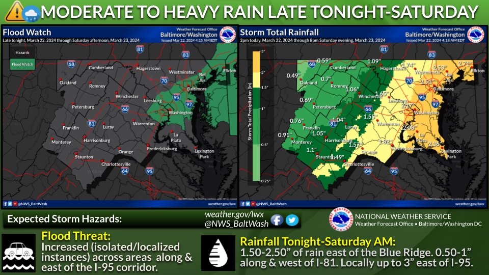
The heaviest rainfall is anticipated to occur along and east of the Blue Ridge, where rainfall totals could range from 1.50 to 2.50 inches. Areas further west of the Blue Ridge are expected to receive slightly lower amounts, between 0.75 to 1.50 inches. While flooding isn’t expected to be widespread, some rises on streams and creeks are likely, particularly within urban areas. Flood Watches remain in effect for the Baltimore/Washington DC metro areas to address this potential threat.
Given the recent dry spell and the absence of a convective element, widespread flooding is not currently anticipated. However, localized flooding in poor drainage areas cannot be ruled out, particularly within the urban I-95 corridor. Despite the rain, temperatures are expected to remain relatively cool, with highs in the upper 40s and low to mid-50s, and lows Friday night dipping into the low to mid-40s.
Looking ahead, the rain is expected to taper off by Saturday afternoon as the system moves offshore, making way for drier and breezier conditions on Sunday and Monday. High pressure will briefly build over the area, offering a respite from the inclement weather. However, forecasters warn that another front and area of low pressure could approach by the middle and latter half of next week, potentially bringing more unsettled conditions to the region.
In summary, residents are advised to prepare for a wet and blustery weekend, with heavy rainfall likely to impact travel and outdoor activities. Stay tuned to local weather updates and exercise caution in flood-prone areas as the system moves through the region.