
 Prince William Parks and Recreation sponsors today’s weather forecast.
Summer Job Alert: Parks and Recreation Hiring Seasonal Workers Now! Want to earn some extra cash this summer and enjoy your job at the same time? PWC Parks and Recreation is now hiring for seasonal jobs.. Camp Counselors, Lifeguards, Cooks and more…
Residents in the Mid-Atlantic region can expect unsettled weather as a low-pressure system tracks up the East Coast, accompanied by a cold front advancing from the Ohio River Valley. According to the National Weather Service, this system will bring a mix of rain, fog, and drizzle to the area through tonight.
The day started with a blanket of mid and high-level clouds, hindering the visibility of low clouds and fog. However, surface observations indicate the gradual advancement of fog and low clouds, driven by light southeast winds. These conditions are expected to persist through the morning, gradually lifting as rain approaches from the southwest later in the afternoon.
While the most significant dynamics are expected along a coastal front to the east, sufficient lift and moisture advection are forecasted to produce rain locally as a mid-level dry pocket is overcome later in the day. Rain is anticipated to be most prevalent late this afternoon and into the evening as the coastal low approaches. Additionally, a front from the west will contribute to lift, albeit briefly, into early Thursday morning before dissipating.
Overall, the region should prepare for periods of light rain, drizzle, and areas of fog through tonight as these weather systems traverse the area. Rainfall totals are expected to be higher along the Chesapeake Bay but are forecasted to remain below an inch overall.
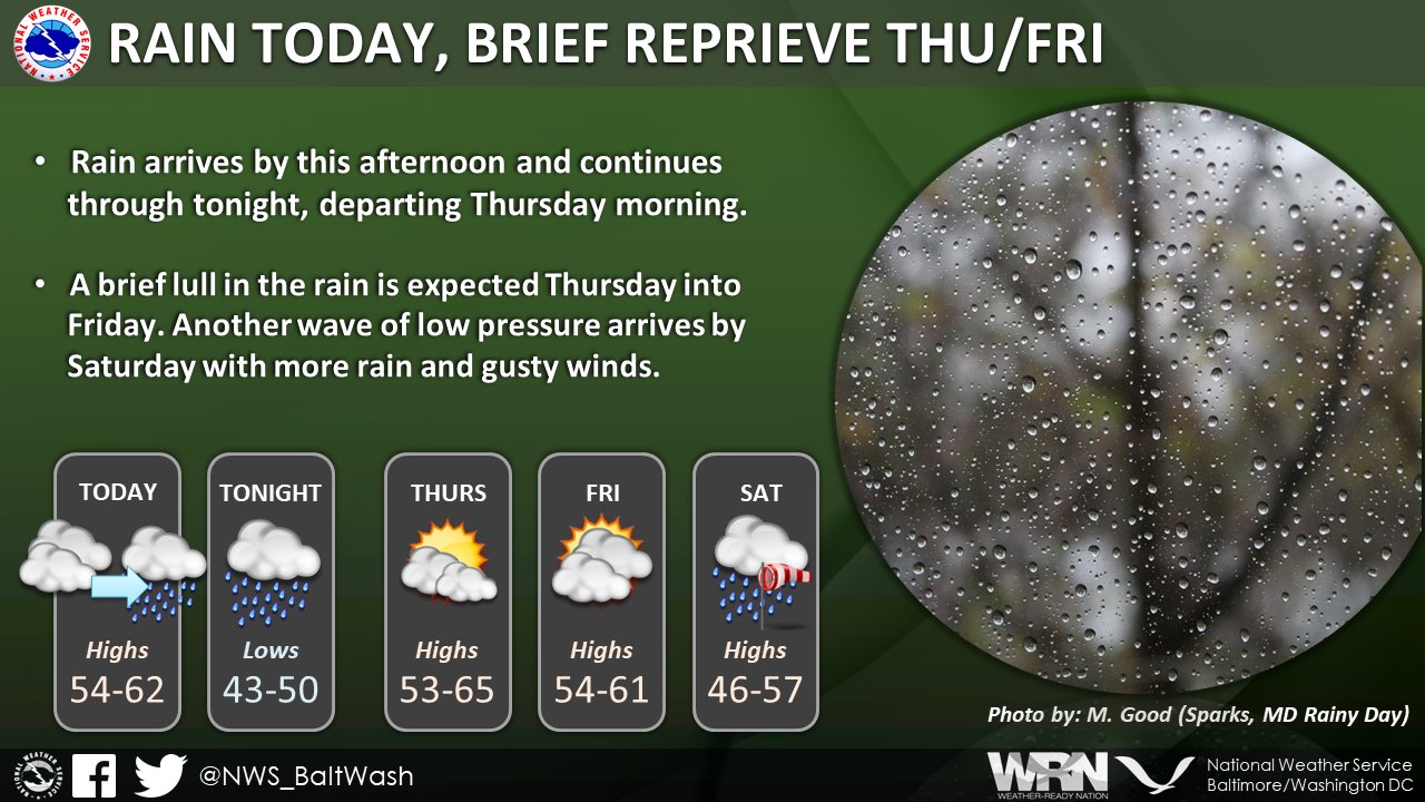
Here is a breakdown of the weather forecast:
- Today: Rain is expected mainly after 10 am, with areas of fog persisting. The high temperature is forecasted to be near 57 degrees Fahrenheit, with an east wind of around 6 mph. The chance of precipitation is 80%, with new precipitation amounts between a tenth and a quarter of an inch possible.
- Tonight: Rain will continue, primarily before 1 am, with areas of fog persisting until around 3 am. The low temperature is expected to be around 49 degrees Fahrenheit, with a north wind of 6 to 8 mph. The chance of precipitation is 100%, with new precipitation amounts between a tenth and a quarter of an inch possible.
- Thursday: There is a chance of rain, mainly before 10 am, with mostly cloudy skies expected throughout the day. The high temperature will be near 63 degrees Fahrenheit, with a north wind of 8 to 10 mph. The chance of precipitation is 30%.
- Thursday Night: Mostly cloudy conditions are expected, with a low temperature around 42 degrees Fahrenheit and a north wind of around 7 mph.
- Friday: Partly sunny skies are forecasted, with a high temperature near 61 degrees Fahrenheit. The north wind will be around 7 mph, becoming southeast in the afternoon.
- Friday Night: There is a chance of rain after 1 am, with mostly cloudy conditions expected and a low temperature around 42 degrees Fahrenheit. The chance of precipitation is 30%.
- Saturday Rain is likely, with a high temperature near 56 degrees Fahrenheit. The chance of precipitation is 90%.