
Prince William County and parts north are under a flood watch until late tonight as heavy rain moves into our area.
According to the National Weather Service, flooding caused by excessive rainfall continues to be possible in Washington, D.C., Maryland, and northern Virginia, including Arlington/Falls Church/Alexandria, Fairfax, Prince William, Manassas, and Manassas Park.
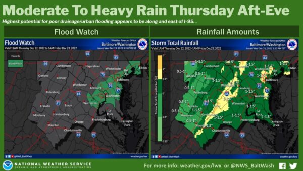
Excessive runoff may result in flooding of rivers, creeks, streams, and other low-lying and flood-prone locations. Flooding may occur in poor drainage and urban areas.
Moderate rainfall is expected Thursday into Thursday evening, with rainfall totals of one to two inches. This may lead to isolated instances of flooding, especially in urban and poor drainage areas.
After the rain moves out tomorrow, Friday, December 23, deep cold — the coldest air we’ve seen this time of year in 20 years — moves into the region. A flash freeze is expected as temperatures will fall from the 50s to the teens.
Here’s the forecast
Tonight
Rain is likely before 1 am; then rain is likely after 4 am. Cloudy, with a low of around 36. Southeast wind 7 to 10 mph, becoming south after midnight. Winds could gust as high as 26 mph. The chance of precipitation is 70%. New precipitation amounts between a quarter and half of an inch possible.
Friday
Rain is likely before 10 am, then a chance of snow between 10 am and 1 pm. Cloudy through mid morning, then gradual clearing, with a temperature falling to around 16 by 5 pm. Wind chill values as low as zero. Breezy, with a west wind of 15 to 21 mph, with gusts as high as 38 mph. The chance of precipitation is 70%. Little or no snow accumulation is expected.
Friday Night
Mostly clear, with a low around 10. Wind chill values as low as -5. Southwest wind 14 to 17 mph, with gusts as high as 33 mph.
Saturday
Sunny, with a high near 24. West wind 10 to 14 mph, with gusts as high as 21 mph.
An approaching low will bring increased moisture to the area during the day on Thursday with mainly a cold rain expected along and east of the I-95 corridor. A Flood Watch is in effect Thurs-Thurs Night for portions of the I-95 corridor where 1 to 2" of rain is possible. pic.twitter.com/ujGojdjT7G
— NWS Baltimore-Washington (@NWS_BaltWash) December 21, 2022