
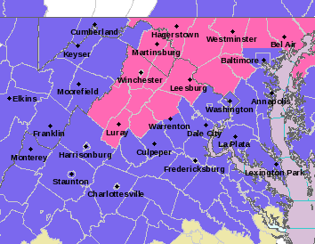
And just like that, the winter storm that could have dumped two to four inches of snow on the area seemed to fizzle.
A winter storm warning in place for Prince William, Greater Manassas, and much of the Washington metro area was replaced by a winter weather advisory. The revised forecast called for one to three inches of snow.
WINTER WEATHER ADVISORY IN EFFECT UNTIL 2 PM EST THIS AFTERNOON…
.REST OF TODAY…SNOW LATE THIS MORNING…THEN SNOW LIKELY THIS
AFTERNOON. TOTAL SNOW ACCUMULATION OF 1 TO 3 INCHES. HIGHS IN THE
LOWER 30S. NORTHWEST WINDS AROUND 5 MPH. CHANCE OF SNOW NEAR
100 PERCENT.
.TONIGHT…MOSTLY CLEAR. LOWS AROUND 17. WEST WINDS 5 TO 10 MPH.
.WEDNESDAY…SUNNY. HIGHS IN THE LOWER 30S. SOUTHWEST WINDS AROUND
5 MPH.
.WEDNESDAY NIGHT…PARTLY CLOUDY. LOWS AROUND 19. SOUTHWEST WINDS
AROUND 5 MPH…BECOMING NORTHWEST AFTER MIDNIGHT.
In areas to the south, including Stafford County, we’ve seen rain mixing with sleet. Fat snowflakes were falling before sunrise but things quickly changed over. The Washington Post’s Capital Weather Gang stated last night that this could happen.
More from their story:
Is there any way this could be a bust? Yes, there is one scenario in which the heavier precipitation misses the metro area to the south, temperatures don’t cool down enough and we end up with some sleet and closer to an inch of snow. We think the chances of this scenario happening are on the low side, but not impossible.